
Search West Milford Streets
Start the West Milford street directory with the address itself, then turn it into a parcel key. The county GIS layer can identify the situs, owner label, block, lot, and deed references. The Clerk index uses a party name, block and lot, document type, or instrument number to continue the legal record trail. A voter lookup can test a named person's registration status, but it is not an address-by-address household roll. Older occupant questions need the library and historic collections after the current property chain has been established.
- Find the address in the county parcel layer and note the municipality, block, lot, PIN, and owner field.
- Use the map service to check adjoining parcels and whether the street spelling is consistent.
- Search the Clerk index with the owner name or parcel key for a deed, mortgage, or other recorded instrument.
- Use the New Jersey voter check only for a particular name and compare it with independent evidence.
- For earlier households, carry the address and locality variant to PCHS, the Township Library, or the State Archives.
The order matters. It stops a road name from being mistaken for a complete address, and it preserves the legal parcel identity when West Milford mailing labels differ from the situs.
Read a West Milford Address
Each West Milford address has at least three useful parts. The situs address is the physical property location. The mailing address is where the tax roll sends notices. The legal description is the block, lot, and other parcel identification used in the property and deed systems. A tax bill or parcel card may show both the situs and a different mailing locality. That difference is common in a township with Hewitt, Upper Greenwood Lake, Newfoundland, Oak Ridge, Macopin, and other names appearing in records.
Keep all versions of an address in the research notes. A parcel search can use the owner name, street address, property location, or ZIP field. A Clerk search works better with a party name, block and lot, or instrument number. The official West Milford street-map index is useful for checking a road name before treating a near match as the same place.
- Situs address
- The physical location of the parcel, not necessarily the owner's mailing destination.
- Block and lot
- The municipal parcel key that should be used together.
- Plat
- A map showing a subdivision or parcel layout; it is not the same as a current boundary survey.
- Criss-cross directory
- A reverse directory arranged by address, where available.
West Milford Parcel Fields
The Passaic County GIS map service supports query, find, identify, and map export functions. Its parcel layer supplies more than a label on a map. Fields include PAMS_PIN, PCLBLOCK, PCLLOT, OWNER_NAME, ST_ADDRESS, PROP_LOC, CITY_STATE, ZIP_CODE, ZIP5, ZIP_PLUS4, deed book, deed page, deed date, land and improvement values, sale fields, and property descriptions. The layer is compiled from state data and digitized tax maps, so it is research evidence rather than a survey.
| Search field | West Milford use | What to check next |
|---|---|---|
| OWNER_NAME | Find a current owner label or name spelling | Recorded instrument index |
| ST_ADDRESS / PROP_LOC | Locate a street-facing parcel | Block and lot match |
| MUN_NAME / PCL_MUN | Keep results in the right municipality | Current layer value |
| PCLBLOCK / PCLLOT | Preserve the stable property key | Tax bill and Clerk search |
| DEED_BOOK / DEED_PAGE | Connect a parcel to land records | Clerk image or copy |
| ZIP_CODE / ZIP5 | Compare delivery geography | USPS address result |
West Milford GIS by Street
For a whole road, map browsing is stronger than a single name query. Start with one known parcel, then use the adjacent blocks and visible road line to identify the next parcel. The service carries Parcel and Block layers and can return records in JSON, GeoJSON, or other supported formats. Queries allow ordering and pagination, but no more than 2,000 records are returned at once. A long road should be checked in smaller stretches rather than treated as one complete household list.
West Milford's scale explains why this is useful. The township occupies more than 75 square miles of land and stretches across Highlands roads, lake communities, and the Route 23 and County Route 511 corridors. A street-only search can miss a record filed under a hamlet or postal locality. Compare the map, the tax map, the parcel PIN, and the street spelling before moving on.
West Milford Tax-Bill Bridge
The local Tax Collector directs payments to the municipal tax-bill service. The search route accepts block and lot, account number, or street address. That makes the tax bill a practical bridge when a street directory search has an address but the county parcel display uses a coded key. The source can show payment or bill context, not a verified list of everyone who lives at the property.
West Milford's current portal coverage is not published as a historical archive, and no public delinquency-list search was located in the research. Save the result date, account or block-and-lot reference, then use the county Clerk record for legal transaction history. Do not assume a tax-mailing field is the occupant field.
Note: A mailing address may identify the person receiving notices, while a street-directory search is usually trying to understand the parcel at the situs.
West Milford Deed Trail
Recorded deeds are the strongest public link between an address and a sequence of owners. The Passaic County Clerk offers a free form with Document Type, Block/Lot, Name, and Instrument Number tabs. Online coverage is advertised back to 1989 for deeds and mortgages and back to 2000 for other documents. Search the apparent current owner as a grantee, note the prior grantor, then repeat the process backward. Check the legal description each time so a similar street number does not pull in a different parcel.
When the online trail stops, go to the Clerk vault or map room, then use older deed books, microfilm, and historical channels. The Clerk does not perform title searches, and a recorded item does not replace a legal title opinion. It does provide the useful next name, date, and legal description for West Milford address research.
Passaic County's free land-record form shows the actual search modes used to begin this leg of the street directory.
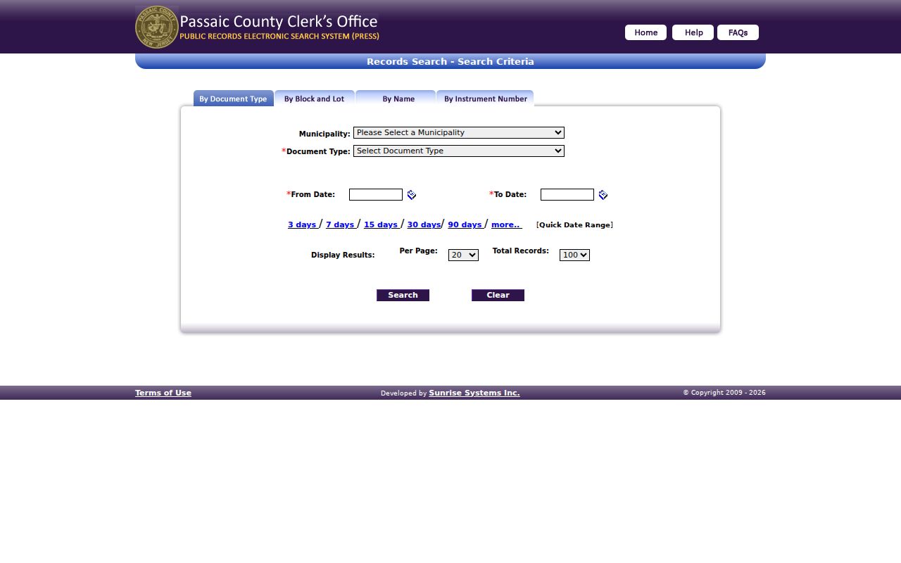
The screen is a starting point for an instrument search, not evidence that every person connected with a West Milford address lives there now.
West Milford Street Records
Address-keyed sources each give a narrow kind of evidence. The county parcel layer is the best current map and ownership start. The tax service links a street to an account or block and lot. Deeds tie parties to a legal chain. Township permit and engineering material can date physical work, but no public historical permit index was confirmed. Voter data and historic collections can help with a named person or earlier household, but neither is a complete street directory.
| Address record | West Milford keeper | Street evidence | Access channel |
|---|---|---|---|
| Parcel/GIS layer | Passaic County GIS | Parcel, owner label, situs, block and lot | Map service or county OPRA |
| Tax-bill search | West Milford Tax Collector | Street, account, or block-and-lot bridge | Municipal payment portal |
| Land records | Passaic County Clerk | Recorded parties and legal chain | Online index, vault, microfilm |
| Permits and zoning | West Milford Planning/Zoning | Application or property-work context | SDL portal, office, or OPRA |
| Historic household material | PCHS and State Archives | Older locality and family leads | Library or archive search |
West Milford Street and ZIPs
Street research should not treat a ZIP code as the township boundary. Official evidence supports 07480 for West Milford, 07421 for Hewitt, and 07435 around Newfoundland and the Route 23 edge. The research also found isolated official records with 07438 and 08848, but not evidence that either is a normal township-wide ZIP. The final delivery check belongs with the USPS ZIP lookup.
Postal labels are an important street-directory filter, but they are not a substitute for the parcel's municipality and legal key. When a ZIP narrows the area but a street needs detailed work, use the map and block-and-lot trail. The West Milford ZIP directory keeps the postal-angle details separate from the complete street workflow.
West Milford Address Permits
Township permits, zoning files, and engineering records can add a physical-history layer to a West Milford address. The Planning, Zoning and Code Enforcement office links residents to the SDL permit portal and says zoning applications are online. Engineering handles roads, drainage, infrastructure, site plans, and a site-plan tracker. These sources can help date work or identify an application record after the parcel has been fixed.
No public historical permit-search interface, address query fields, or coverage period was located in the research. Use the portal for current applications, contact the relevant office for a specific record, or make a focused OPRA request. Include the address, block and lot, date range, and document type. That precision is more useful than an open-ended request for everything on a street.
West Milford Street Directory Gaps
Older criss-cross books can sometimes place a household at an address, but the local collection must be checked before relying on its title. PCHS documents Passaic County directories from 1856 through 1968 and selected pink street pages, yet West Milford is not among the municipality set listed for that run. The omission is valuable research information. It means a missing name can reflect the book's coverage, not a person's absence from the township.
For an old West Milford address, ask the Township Library and PCHS about separate telephone, map, manuscript, cemetery, or family material. Search Macopin and Newfoundland along with West Milford. The historical collections themselves belong on the West Milford city directory page; the street directory uses them only after the parcel and road have been established.
West Milford Street Limits
A street directory cannot show every person who resides at an address. Renters and other household members may not appear in land records. Driver-license and utility customer information are not public street-roll substitutes. Court results can be sealed or otherwise excluded. ACP and Daniel's Law can also remove qualified addresses from public products. A missing result is not permission to search around a protected person.
Lawful use. West Milford street and address records support personal, family-history, property, civic, and safety research; never use a result to stalk, harass, intimidate, or harm anyone.